

“Threat to Life” Warning as Ireland Braces for Storm Éowyn’s Wrath
A Red Wind Warning has been issued for all 26 counties of the Republic of Ireland, as Met Éireann warns of a “danger to life” due to severe, destructive winds brought by Storm Éowyn. The warning, effective at different times starting 2:00 AM local time on Friday, will extend through various regions and is expected to cause widespread disruption.
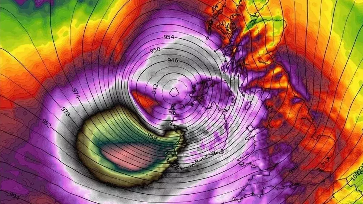
Record-Breaking Storm Set to Batter Ireland
Storm Éowyn, described as potentially one of the most intense storms in Irish history, could bring gusts of up to 130 km/h. Keith Leonard, chair of the National Emergency Co-ordination Group, cautioned that conditions will be “among the severest storms Ireland has ever seen.” He also emphasized that serious power outages and transport chaos are anticipated, with potential outages surpassing the 385,000 customers affected during Storm Ophelia in 2017.
Met Éireann has urged residents in red warning zones to stay indoors until the alert is lifted, adding that hazards like fallen debris and downed trees will persist even after the storm passes.
Counties and Warning Timelines
Here’s when the red wind warning will come into effect across the Republic of Ireland:
- From 2:00 AM to 10:00 AM Friday: Carlow, Kilkenny, Wexford, Cork, Kerry, Limerick, and Waterford.
- From 3:00 AM: Clare and Galway.
- From 4:00 AM: Leitrim, Mayo, and Sligo.
- From 6:00 AM to 3:00 PM: Cavan, Monaghan, Dublin, and 14 other counties, including Donegal.
In addition to the wind alerts, a Yellow Rain Warning will be in place for Cork, Kerry, and Waterford between 9:00 PM Thursday and 3:00 AM Friday, raising concerns about coastal flooding and wave overtopping in vulnerable areas.
Schools and Workplaces Closed
In response to the life-threatening conditions Éowyn , the National Emergency Co-ordination Group has ordered all schools, childcare facilities, and higher education institutions in red-warning zones to remain closed for the duration of the alert. Employers are also encouraged to allow remote work for non-essential staff, while only emergency service workers should travel during this period.
Northern Ireland Prepares for Storm Impacts
The Met Office has issued a Yellow Wind Warning for Northern Ireland, starting midnight Thursday and lasting until Friday night. Winds of 50-60 mph (80-100 km/h) are expected inland, with stronger gusts along coastal areas.
The warning will escalate to Amber, the second-highest level, from 6:00 AM to 9:00 PM Friday. During this period, wind gusts of up to 70 mph (115 km/h) are expected widely, with coastal and hilltop areas potentially seeing speeds up to 90 mph (145 km/h).
Potential Hazards
In both the Republic of Ireland and Northern Ireland, the storm poses significant risks, including:
- Power outages: Large-scale blackouts are expected due to downed power lines.
- Travel disruption: Severe delays and cancellations for road, rail, and air transport are likely.
- Structural damage: High winds could damage buildings, infrastructure, and vehicles.
- Injuries: Flying debris, falling trees, and large waves pose a direct threat to safety.
The Strongest Storm in Decades?
Experts suggest the wind speeds brought by Storm Éowyn could rival those recorded during Storm Debbie in 1961, one of the most catastrophic storms in Ireland’s history. This marks Éowyn as the fifth named storm of the 2024-2025 winter season, following Storm Darragh in December.
Safety First: How to Prepare
Residents in affected areas are urged to take precautions, including:
- Securing outdoor furniture and loose items.
- Avoiding coastal areas and open spaces during the storm.
- Keeping emergency supplies, such as torches and batteries, on hand.
- Monitoring updates from Met Éireann, the Met Office, and local authorities.
Conclusion
Storm Éowyn is shaping up to be a historic weather event, with potentially life-threatening winds and disruptive impacts across Ireland. Whether you’re in a red zone or an amber warning area, the key to staying safe is preparation, vigilance, and heeding official advice.
Stay safe, and monitor local updates for real-time information as this powerful storm makes landfall.


